100 Florida Trails®
Top FL Multi-use Bike Trails
Map Links & Photos Galore
Coast-to-Coast Updates
You are here > Home >
Trails >
Everglades National Park
Latest update: February 2025
Trails... Everglades National Park, Florida
4 Paved Bike Trails... E-Z Maps, Photos Galore (scroll down page or use links below)
Color-coded in blue on map (*scroll in to view)...
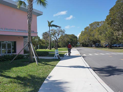
Flamingo & Guy Bradley Trail, biking at
the Guy Bradley Visitor Center, south entrance
Chokoloskee Causeway Trail, starting at Gulf Coast Visitor Center, plus 2 tiny towns to explore
Shark Valley Trail, Top 10 FL Trail, bike with alligators, north entrance
Aerojet Road Trail, in the Southern Glades Wildlife and Conservation
Area, near National Park south entrance
Unpaved Trails & Levees... "Eco-biking"
Color-coded in green on map...
Everglades Eco-biking,
for a list of hiking and fat tire biking
options in or near Everglades National Park. Check out photos along three historic
roads and on dirt and gravel levees just outside the National Park.
Trails Overview... Everglades National Park, FL
South Florida... Everglades National Park
4 Paved Trail Options in or adjacent to Everglades National Park. Please note: while the Park Service lists the main Park road between Coe Visitor Center and Flamingo as an option for cyclists, we do not recommend biking or hiking on the main Park road (other than within Flamingo itself).
Flamingo Visitor Center - Guy Bradley Trail
Flamingo is not a primary Everglades destination for biking (unlike Shark Valley for example). But even limited biking and hiking can be a fun part of the overall experience. The Guy Bradley Trail is a scenic paved pathway along Florida Bay from the Visitor Center to the Campgrounds (1.2 miles round-trip) - popular for biking and walking, wheelchair compatible. Enjoy the views of Florida Bay, assorted birds and butterflies.
The Guy Bradley Visitor Center offers parking, restrooms, gift shop, information, brochures and exhibits. Flamingo Lodge and Restaurant, the Flamingo Campground and other camping facilities, Flamingo Marina and Marina Store, public boat ramp, and hiking and paddling trails are located nearby, connected by road and trail.
Please see full page trail report -- Flamingo, Everglades Biking, Map, 60+ Photos
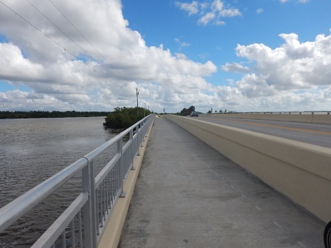
Gulf Coast Visitor Center - Chokoloskee Causeway Bike Path
The Chokoloskee Causeway Path, starting at the Gulf Coast Visitor Center in Everglades City, runs 3 miles to the marina at Chokoloskee Island . The path runs roadside mostly as a wide sidewalk, while the bridge along the causeway has a separated walk/bike lane, always a nice feature. While the trail isn't long, it offers water views and great sunsets.
Visit Everglades City (pop. 426) and Chokoloskee (pop 359) - these small, laid-back towns at either end of the causeway offer additional miles of casual biking, sightseeing, history, and seafood.
Please see full page trail report -- Chokoloskee Causeway Path - Gulf Coast Visitor Center, Map, 35+ Photos
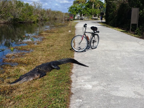
Shark Valley Visitor Center - Shark Valley Tram Trail
The Shark Valley Tram Trail - a Top 10. This is truly one of the most unforgettable bicycle rides in America. Located entirely within Everglades National Park (north entrance), west of Miami off the Tamiami Trail (US 41) beside the Miccosukee Indian Reservation, the Shark Valley Trail is a 14.5 mile paved loop traveled by bike, foot, or Park tram. Bikes can be rented at the Visitor Center, or bring your own. You will typically see far more wildlife along the canal on the west side. The most expansive views are on the east side. Best in cool weather, you will soon get used to riding past and at times around - unless you wait for a tram - alligators of up to 10 or 12 feet long. No worries. They will hiss like a cat if you get too close. Bring a camera and plenty of water.
Please see full page trail report -- Shark Valley, Map, 45+ Photos
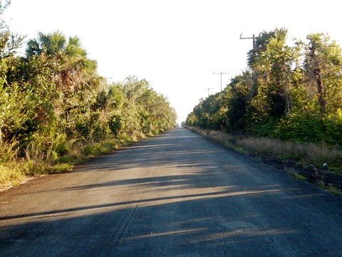
Southern Glades Wildlife and Environmental Area - Aerojet Road Trail
Aerojet Road Trail starts at the Southern Glades Wildlife and Environmental Area (WEA) Trailhead along SR 9336, outside Everglades National Park (south entrance), about one mile east of the Coe Visitor Center. The paved, 5 mile trail runs on abandoned road that served the former Aerojet Dade Rocket Facility. Running along the Aerojet Canal, it's now popular for biking, hiking, and birdwatching.
Please see full page trail report -- Aerojet Road Trail, Map, 30+ Photos
More Information and Resources
Nearby Biking:
Everglades Eco-biking
- unpaved "fat tire" biking at Everglades National Park
South FL Overview - all 3 South FL Regions,
with Regional Overview Map
Nearby Paddling:
Kayaking at Everglades National Park at PaddleFlorida.net
Related Resources:
National Park Service - Everglades National Park
Everglades National Park - Bicycling
Everglades National Park - Hiking
Find Trails by FL Region or Listed A - Z

100FloridaTrails.com... 100+ Florida Multi-use Bike Trails, Best for Safe, Fun Recreation and Fitness
Other Websites:
BikeOrlando.net
PaddleFlorida.net
BikeTripper.net
Copyright © 100FloridaTrails.com. All Rights Reserved.