You are here > Home > Top Ten > Jacksonville Baldwin Rail Trail
Jacksonville-Baldwin Rail Trail... Florida
A FL Top 10 Bike Trail... E-Z Google Map, Ride Photos Galore
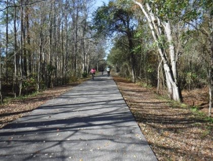
Although just outside Jacksonville, FL, this is an enjoyable rural bike ride - well maintained (kudos to the Florida Department of Transportation and Jacksonville-Baldwin Trail volunteers) and for the most part, tree-lined with virtually no traffic noise. Benches and trash cans are at regular intervals. Bring your own food and water - no restaurants or latte shops! (Map link and photos below.)

Location: Duval County
End Points: Jacksonville, Imeson Road Trailhead to Brady Branch Road, west of Baldwin, FL
Mileage: 14.5 miles
Surface: Paved asphalt, 12 ft.
Trailheads at Imeson Road, Camp Milton, Halsema
Road, Baldwin (Center St.), and Brandy Branch Rd.
Nearby points of interest: Camp Milton Historic
Preserve Civil War site (about 6 miles west of the Imeson trailhead)
Bike Shops/Rentals:
Trek Bicycle - Jacksonville Lakeshore (Jacksonville)
Support and Advocacy
Page Summary:
- Biking the Jacksonville-Baldwin Trail
- Eastern Section - Imeson Trailhead
to Halsema Trailhead and Camp Milton
- Imeson Trailhead, Hannah Road, Halsema Trailhead, Camp Milton Historic Preserve - Western Section...
Halsema Trailhead to Baldwin and Trail End
- Baldwin Trailhead, Brandy Branch Trailhead - More Information and Resources
Biking the Jacksonville-Baldwin Trail... Comments and Photos
There are no congested road crossings anywhere along the trail. Most of the "Vehicle Crossings" signs you will see are for gated forestry-service roads that haven't been used in years. Natural habitats include pine flatwoods, wetlands, and hardwood uplands. Wildlife includes hawks, songbirds, wild turkey, turtles, snakes, and deer. A few roosters make their presence known. An equestrian trail parallels the Jacksonville-Baldwin Trail. We like parking at Camp Milton near the midpoint - quiet, tree-lined, and full facilities (more below). Photos show the trail from east to west and mileage is approximate.
Eastern Section - Imeson Trailhead to Halsema Trailhead and Camp Milton
Imeson Trailhead to Hannah Road (3.5 Miles)
From the eastern Imeson trailhead, the first 3.5 miles of the Jacksonville-Baldwin Trail are mostly open, with wide grassy shoulders and a good field of view, including woods, fields, and residential areas. Since the trail here follows a power line, there is little shade - unlike much of the rest of the trail. Proximity to Jacksonville, ample parking and restrooms make this an active section, with many family groups in addition to long-distance and recreational bikers - observe the 20 mph posted speed limit. Less than a mile from the trailhead, Commonwealth Ave. is the busiest road crossing on the entire trail.
Hannah Road to Camp Milton and the Halsema Trailhead (2 Miles)
After the first 3.5 miles, the trail leaves the power lines and enters a nice tree-lined corridor. Here, it's about 2 miles to the Camp Milton Historic Preserve (more below) and the Halsema Road Trailhead. Full facilities are along the trail adjacent to Camp Milton (paved parking, short path leads to bike trail). Across the road and fronting the trail, the unpaved Halsema Trailhead serves as the main equestrian trailhead, with horse trailer parking and a horse wash rack. Perhaps for the shade, we see many cyclists park here on the dirt fronting the trail. Whatever one's choice, we rate either trailhead as best for recreational bikers - near the mid-point, in the shadiest trail section, fewer people than at Imeson, ride for miles with no difficult road crossings, and for a pleasant hike and bike (OK on the path) through the Historic Preserve, get a rare glimpse of some Florida Civil War history.
Camp Milton Historic Preserve
Camp Milton Historic Preserve serves as a trailhead for the trail, which forms its northern boundary. Rarely crowded, there is plenty of paved parking, with a short paved path (parallel to Halsema Road) leading to the bike trail. Bicycles are allowed on the dirt path in the Preserve. In addition to parking and the historic exhibits, amenities include restrooms, benches, bike racks, hiking and equestrian trails.
Civil War buffs will want to explore the preserve and historic exhibits. Camp Milton served as a Civil War encampment and fortification, the largest in Florida, once housing 8,000 Confederate troops. More about Camp Milton Historic Preserve .
Western Section - Halsema Trailhead to Baldwin and Trail End
Halsema Trailhead to Baldwin Trailhead (7 Miles)
The narrow, tree-lined corridor continues virtually uninterrupted for about 6 miles - with only one real road crossing (Otis Road), this is the type of serene riding we love. At mile marker 12, the trail enters an open residential area and goes under US 301, before arriving at the Baldwin Trailhead. The old Baldwin train depot serves as a Visitor Center with restrooms and parking, though the office was closed when we visited. The community park here has picnic facilities, a fitness path, playground, and a railroad caboose exhibit.
Baldwin Trailhead to Brandy Branch Trailhead (2 Miles)
The last 2 miles of the trail to Brandy Branch Road is a little more open but still mostly shady. The Brandy Branch trailhead has parking and a port-a-potty.
More Information and Resources
Nearby Bike Trails:
Black Creek Trail (north)
Timucuan Trail
Amelia Island Trail
North FL Region - see Regional overview map for trails near you
Related Resources:
City of Jacksonville - Jacksonville-Baldwin
Rail -Trail
City of Jacksonville - Jacksonville-Baldwin Rail Trail brochure & map (.pdf)
Timucuan Parks Foundation - Jacksonville-Baldwin Rail Trail
